


And so we went down to the sea – or rather, up and down the forested hills, past the nursery, along the golf course, over suburban streets, up and down the coastal headlands to the sea.
To paraphrase the start of Moby Dick, “Whenever I find myself growing grim about the mouth; whenever it is a damp, drizzly Wellington August in my soul; whenever it requires a strong moral principle to prevent me from deliberately stepping into the street, and methodically knocking people’s hats off — then, I account it high time to head down the walkway to the sea as soon as I can.”

So, after days of dank rain and dark cloudy skies, we needed to get on our feet and make some walk, any walk, ideally to the sea. Since Nancy was back in the States and had not enjoyed the walk to Brooklyn with Barry (see a Walk on the Wild Side), we decided to repeat the trip. This time, however, we left early enough to do the whole trek from Wellington central to Island Bay on the South Coast, the City to Sea Walkway through over a dozen parks, preserves and forests.
Picking up the trail near our house, it’s about 12 kilometers (or 7.5 miles) all the way, with innumerable 150-200 foot rises and falls along the way, and near the finish a 500 foot ascent before it’s down to the sea.

There is also a movement through time as well, from large nikau palms and mamaku tree ferns thriving before the Maori to the city’s nursery for greenery at roundabouts and boulevards, from primordial scrubland to planted grass designed to withstand the abrasion of cleats or promote a golf ball’s bounce, from buildings over a hundred years old like the neo-gothic Erskine College and neighboring Victorian bungalows to contemporary townhouses on the hillsides, from three hundred year old legends and sacred places to boldly painted playgrounds.
After Central Park, which connects the city to Brooklyn, we continued to trek similar terrain in a string of rough forested preserves, furzy meadows and manicured parks. Along the way, we relished aerial views back to the Wellington harbor and surveyed the city’s overflow of homes down valley to the sea: Newtown, Berhampore, Island Bay, and the benignly named Happy Valley.

One oddity was the portion of the trail along the 17th fairway of the city’s Berhampore Golf Course ($16 per round). We were headed one way along the edge of the fairway, and a threesome sporting yellow shoes and iridescent balls was slicing its way in the other direction. They barely gave us a look.

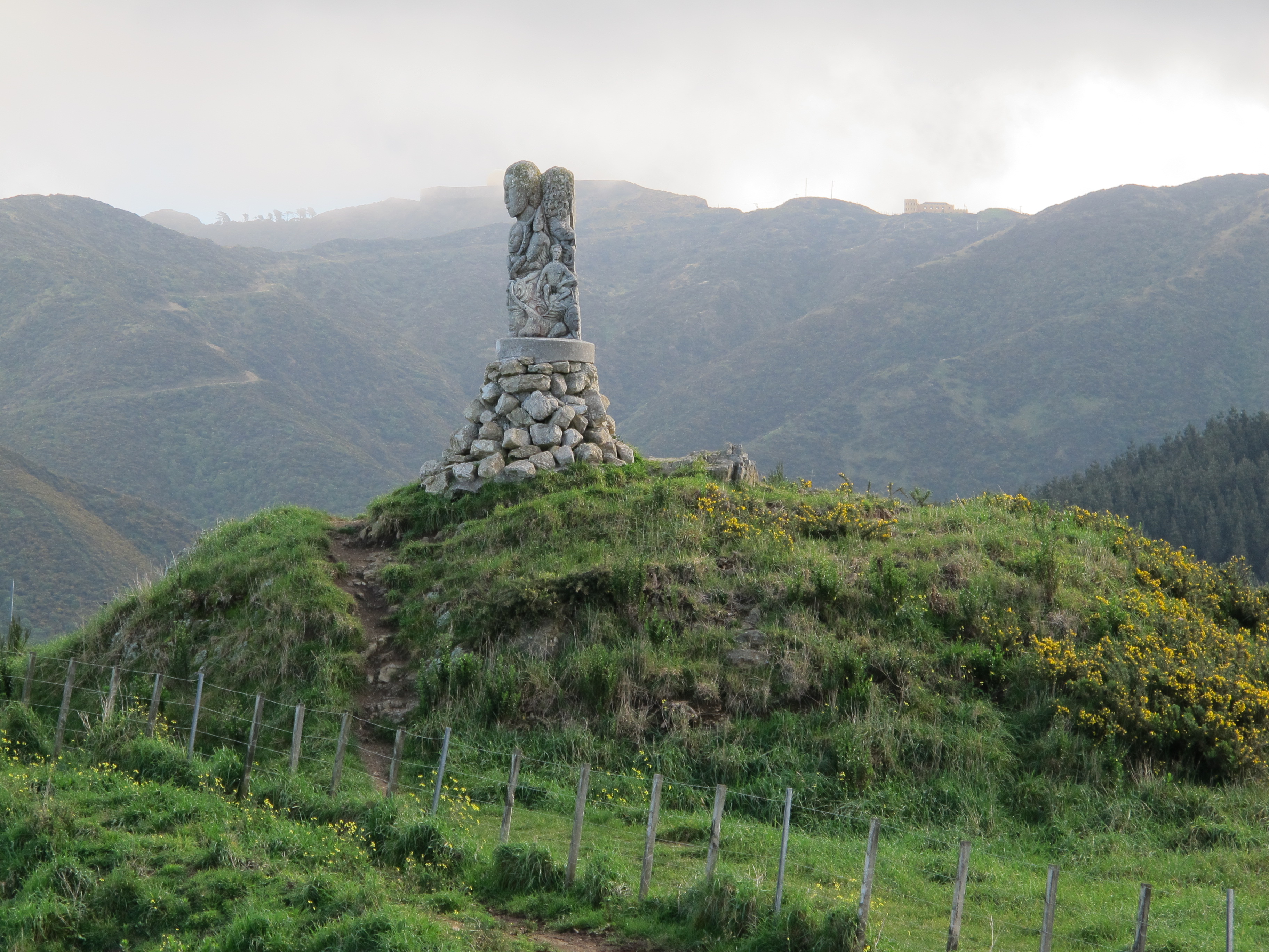
When we left the golf course behind, we switchbacked up the steepest climb of the walk. Incongruously, below us, houses filled the valley beyond the course, but up here in the wild scrubland and woods we saw the sea before us and headed through Maori tribal lands dating from the early 18th century. Here tribes led by Te Rauparaha looked also to the sea, though for their sustenance or for protection on the island Tapu Te Ranga. And they recalled their former homelands past the mountain ranges to the north. In the same spirit, their descendants placed a memorial powhenua up top, staring in both directions.

A gradual drop from the ridge led us into the suburban streets and apparently the end of our trip. We had not hiked this far or with this much cumulative vertical since last March, so our legs were a bit tired and thighs achy. But there was one more climb in the last reserve on the trail to a compact ridge overlooking the southern bays of the coast and the town of Island Bay. Once again, steeply beneath, the human landscape sprawled below but, on the other side of the ridge, the vast open sea was dotted only occasionally with boats. The sweeping blue horizon before us hid the distant shores, southward 2000 miles to Antarctica and westward 50 miles to the South Island of New Zealand across the Cook Strait.

And then a last descent toward Island Bay and the Number 1 bus back to central Wellington. As the preserve yielded to the city streets on the hillside, we missed a turn and found ourselves instead at a dead end with a single house. The owner just happened to be coming up some adjacent stairs as we arrived, porting his road bike. As Kiwis do, he kindly asked if we needed help and invited us to finish our descent by that private stair (which he pronounced more like “steer”), but “mind the slippery section!” Ohh, mercy. The steer, err.. stair, turned out to be the most precarious part of the trip: first, a stretch of sloping mud where someone had dug uncertain footholds, then a hop/skip section across two sewer covers to a three foot drop, and finally a sharp incline of narrow canted steps hemmed in by vines and sodden bushes.
In four and a half hours, we had been to the sea, we had revisited the tribal past, and we had dared the private stairs. What remained? A comfortable half hour bus ride from the children’s playground at Shoreland Park and a visit to the adult playground of Cuba Street for some well-earned Monteith’s Original Ale.
(For the town brochure of the City to Sea Walkway, go to http://www.wellington.govt.nz/services/walkways/pdfs/citytosea.pdf.
And for more pictures from New Zealand,
CLICK HERE to view the slideshow at the end of the New Zealand itinerary page.)
You definitely have a gift for writing.